


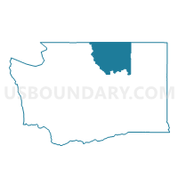
Brewster 6 Voting District, Okanogan County, Washington
About
Outline

Summary
| Unique Area Identifier | 687681 |
| Name | Brewster 6 Voting District |
| County | Okanogan County |
| State | Washington |
| Area (square miles) | 0.04 |
| Land Area (square miles) | 0.04 |
| Water Area (square miles) | 0.00 |
| % of Land Area | 100.00 |
| % of Water Area | 0.00 |
| Latitude of the Internal Point | 48.09664280 |
| Longtitude of the Internal Point | -119.77903410 |
Maps


Graphs
Select a template below for downloading or customizing gragh for Brewster 6 Voting District, Okanogan County, Washington


Neighbors
Neighoring Voting District (by Name) Neighboring Voting District on the Map
- Brewster 2 Voting District, Okanogan County, WA
- Brewster 3 Voting District, Okanogan County, WA
- Brewster 4 Voting District, Okanogan County, WA
- Brewster 5 Voting District, Okanogan County, WA
- Brewster Flat Voting District, Okanogan County, WA